Uppteam

  1. Home
  2. >
  3. Civil design
  4. >
  5. Grading & Drainage

Approval-Guaranteed Site Grading for US Land Development Projects

  1. Home
  2. >
  3. Civil design
  4. >
  5. Grading & Drainage

Approval-Guaranteed Site Grading for US Land Development Projects

Grading Plans

Uppteam’s Grading Plan service offers coordinated proposed surface models and ready-for-sheet grading drawings, clearly defining finished elevations, surface tensions, and constructible earthwork intent. All we want from our clients is boundary survey, topographic data, benchmark information, and municipal-level grading protocols. We ensure every deliverable is consistent with US permitting standards and the client’s Engineer of Record’s direction.

Our Grading Plan Development Workflow

Uppteam extends grading production support using Civil 3D-based surface modeling and documentation workflows. You can expect the following:

x

Prevailing and projected TIN surface creation

x

Finished Floor Elevation (FFE) and building pad coordination

x

Spot elevations, breaklines, and contour development

x

Pavement, sidewalk, and hardscape grading layout

x

ADA-conforming walkway and parking slope annotation

x

Daylight lines and slope tie-in detailing

x

Grading sheet compilation according to local jurisdiction standards

x

Earthwork phase grading exhibits, if needed

Cut/Fill Analysis

Ensuring optimal cost control, grading feasibility, and construction planning requires error-free cut and fill evaluation. For every type of land development project in the US, Uppteam supports the development of existing and proposed surface comparisons in Civil 3D to quantify earthwork volume and confirm grading intent before submitting a permit or construction pricing. Our methodical Cut/Fill analysis benefits from:

Precise earthwork volume calculations

Early detection of import/export requirements

Improved mass grading and site balancing

Minimized construction cost uncertainty

Better feasibility validation during concept design

Clear earthwork exhibits for contractor and client review

Minimal redesign during permitting

Drainage Strategies

The primary focus of Uppteam’s drainage layout production support is on creating well-coordinated surface runoff layouts. We also ensure optimal alignment with municipal stormwater norms and the hydraulic design intent of the Engineer of Record. Leveraging Civil 3D grading and pipe network tools, our structural experts specify overland flow paths, collection points, and storm structure coordination.

What to Expect in Drainage Strategy Development

Adhering to US land development standards, we deliver extensive drainage drafting and modeling support. Send us your project specifications for:
x

Surface runoff flow path delineation

x

Swale grading and channel slope definition

x

Rim and invert elevation coordination

x

Storm inlet and catch basin placement layout

x

Initial detection/retention pond grading geometry

x

Positive drainage authentication throughout pavement and landscape areas

x

Drainage area exhibit preparation

x

Support for storm sewer plan sheet drafting

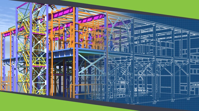
Early Layout, Parking & Fire Access Coordination

Coordinating grading early explicitly impacts the feasibility of a site, ADA compliance, emergency access clearance, and permit review schedules. Uppteam assists clients’ civil teams in modeling initial pad elevations, parking slopes, and fire access paths in Civil 3D. This approach helps us validate constructability before advancing design development under the Engineer of Record's direction.

Make us your partner to ensure:

ADA-compliant parking cross slopes (usually ≤ 2%)

Accessible route longitudinal and cross-slope compliance

Drive aisle and pavement transition continuity

Fire apparatus access grade validation, maintaining local fire codes

Turning radius overlay coordination for emergency vehicles

Early detection of grading conflicts with building pads

OUR Projects

ARTICLES

Connect With Us Today

We’re excited to know about your project details! Please fill out the form below.

    FAQ’s

    We rely on publicly available geospatial datasets and data provided by you or local surveyors. Our team can also integrate data from various sources, such as GPS, LiDAR, and remote sensing technologies, to ensure accuracy.

    We provide specialized GIS mapping support for various industries, including urban planning, environmental management, agriculture, infrastructure development, and utilities.

    Yes, we can integrate GIS data with CAD software like AutoCAD and BIM platforms, enabling seamless collaboration between geospatial data and design workflows.

    We have a multi-layer QC process to minimize errors. In addition, our in-house quality assurance team checks the documents before they are delivered.