Architectural Services
AR for Construction Verification: How to Make 3D Models Field-Ready
-
Sreela Biswas
- November 17, 2025
- 10:15 am
Complete Architectural Construction Document Production In Your Company Standards
Our degreed and trained architectural designers in India work as an extension of your staff on a monthly and hourly subscriptions.
Uppteam’s licensed expert MEP designers, operating remotely, collaborate with US AEC firms to deliver code-aligned MEP design solutions.
Offshore structural design experts deliver top-quality, code-compliant designs and documentation for US projects.
Seasoned civil designers remotely provide unmatched support for advancing site development, grading, and utility plans with sheer accuracy.
Cutting-edge 3D modeling and clash-coordinated documentation empower construction-ready
project delivery.
Dedicated offshore admin teams streamline architect, contractor, and engineering workflows.
Independent and guaranteed error-free model audits, clash detection, and construction
document verification by a specialized team.

U.S.-based local architectural representation, ensuring communication, accountability, and delivery expectations, managed close to the client.
Explore more
Discover our architectural design excellence through a curated selection of projects.
Explore more
Take a look at how Uppteam can elevate your projects with expert engineering solutions.
Explore more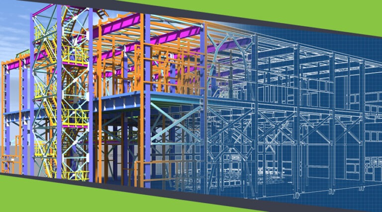
Our Structural Support Services can enhance your structural engineering projects with expert support.
Explore more
Uppteam delivers precise and reliable surveying and mapping solutions to help you make informed decisions.
Explore more
Whether you're working on residential, commercial, or industrial buildings..
Explore more
Uppteam’s Virtual Admin Support can help you with all your administrative tasks..
Explore more
Our experts work as your 3rd party quality control support partner.
Explore more
The twenty-first century has seen numerous technological advances that have influenced the entire spectrum of construction. Augmented reality is one such technology. Professionals in this industry have repeatedly vouched for this cutting-edge technology, which has revolutionized the whole sector. When it comes to construction verification, AR has made a big difference for AEC businesses operating in the U.S.
AR helps overlay 3D models explicitly onto physical job locations, fostering instant comparison between design intent and real-life construction progress. This competence transforms the way teams spot errors, coordinate across verticals, and authenticate installations before expensive rework occurs. If 3D models are ideally prepared to be used in the field, AR becomes a potent quality assurance tool that expedites decision-making and minimizes project delays.
Traditional verification methods pose multiple challenges for construction businesses because of their over-reliance on paper-based inspections, manual calculations, and physical site visits. The combination of AR technology and well-coordinated building information models offers teams great opportunities to validate precision and uphold schedule integrity throughout the project.
Developing 3D models for AR field use requires a straightforward, step-by-step procedure. A field-ready model ought to comprise error-free geometric data, exact spatial positioning, and comprehensive information regarding each component that on-site teams need for validation. This actually goes beyond traditional design models. Remember that field-ready models play the role of accurate digital twins that AR systems utilize as reference geometry during field visualization.
The American Institute of Architects has defined Level of Development (LOD) standards. They demonstrate the level of detail and reliability every model element needs. Concerning AR applications, models usually need to attain LOD 350 or higher, including coordination systems, interfaces between disciplines, and modified element details ready for construction validation.
Devoid of appropriate LOD specifications and compliance, AR systems cannot precisely overlay digital data onto physical components. This renders the technology ineffective for quality assurance.
Below are the vital requirements for AR field-ready models:
Do you know what is at the heart of preparing field-ready 3D models? The answer is simple: clash detection and resolution. When MEP, architectural, and structural systems clash in the digital model, the same challenges emerge during field construction. The result of this is costly rework and schedule delays.
Consolidating all discipline-specific models into a single coordinated BIM environment is the first step toward efficient clash coordination. In this provision, platforms such as Autodesk Navisworks play a critical role. Such types of tools can automatically spot hard, soft, and time-based clashes.
After identifying the conflicts, project teams can convene to address clashes by means of design changes, element rerouting, or repositioning. Moreover, all of these should be documented in the coordinated model. Then, this model becomes the primary source document for AR field verification, as it signifies a constructible, conflict-free design that on-site teams can depend on.
Keep in mind that the coordination procedure should be concluded prior to actual construction work. In contrast, by the time teams reach the construction stage, and if the clashes are not resolved, AR field verification becomes ineffective. This is because the digital reference no longer aligns with buildable reality.
Every discipline updates its model only by following coordination decisions, and the ultimate clash check validates conflict-freeness. This clearance procedure assures that when AR systems overlay the model onto the site, field personnel see an accurate representation of desired installation locations. Consequently, confusion and verification time remain minimal.
Before using BIM models for AR verification, they should go through stringent quality checks. Here, auditing model accuracy follows a systematic review of digital models against design specifications, on-site measurements, and industry standards. There are three main goals of such audits: whether geometric data aligns with design intent, whether every system component is ideally positioned, and whether the dimensional precision matches construction tolerances.
Moreover, 3rd-party quality assurance experts investigate if BIM models comply with U.S.-based project-specific requirements, regulatory standards, and building codes. Next, the validation process is a critical step and involves multiple essential checks. Design quality checks make sure materials, dimensions, and architectural particulars are correct. MEP clash reviews confirm that MEP systems fit together without any conflict.
The role of construction QCs is to examine the integrity of structural data, guaranteeing that columns, beams, and slabs coordinate without any errors. Then there is the model-completeness verification. It authenticates whether all required components are included, along with the proper organization of work sets and the removal of unwanted groups. Therefore, when these validation steps are performed in detail by experts, the resulting model can be trusted for AR field applications. This final model accurately shows what on-site teams can expect to construct.
Particular preparation steps should be followed to ensure field-ready 3D models are functioning efficiently within the AR application. Here, the first step is to determine coordinate accuracy and establish site georeferencing. There are AR systems that can place digital holograms with millimeter precision on-site. However, this accuracy is dependent on models being appropriately georeferenced to the physical location.
Teams are responsible for embedding coordinate information within the model, merging digital elements with real-life site coordinates through GPS, total station data, or laser scanning reference points.
Data standardization is another critical step. It is vital to ensure all model components possess consistent, machine-readable features that AR applications can access and show live. This implies standardization of element naming conventions, creating uniform property definitions across all disciplines. It also confirms compatibility with the particular AR software that field teams will use.
Furthermore, optimizing model files makes sure that AR devices are capable of loading and rendering complex models rapidly without any lag. Bear in mind that this may require simplification of non-critical geometry details, minimizing file sizes, and arranging model content hierarchically. The main benefit of this is that AR systems would load only relevant data for particular field activities.
Without a doubt, AR has changed the way construction teams verify work on-site. Rather than depending on paper drawings, crews can utilize AR to view 3D models over actual structures, spotting differences between design and real-world conditions instantly. This accelerates inspections, curtails errors, and assists in fixing issues early.
AR also boosts teamwork and coordination. Remote engineers can direct field staff using mobile devices, and safety checks can be performed virtually. The system automatically stores photos and measurement-related data, avoiding paperwork and enhancing accuracy. For AEC firms, AR fosters expedited inspections, fewer errors, and consistent quality throughout projects.
Uppteam brings to the table BIM and 3rd-party QC services, working collaboratively to create models that on-site teams can verify with confidence using AR. Our BIM experts develop unified 3D models from LOD 100 through LOD 400, incorporating accurate geometric data, system coordination, and clash detection.
Uppteam also ensures converting laser scan information and point cloud data into site-accurate BIMs that maintain exact spatial connections throughout, across all building elements. Expert designs in our team use cutting-edge BIM software, such as Autodesk Revit and Navisworks, to confirm discipline coordination and detect conflicts before actual site work begins.
Next, our 3rd-party QC specialists validate these models by performing robust audits, verifying accuracy, completeness, and adherence to construction standards.
Your One-Stop MEP Design Support Solution is Here
Hire Remote Team at an Affordable Price!